
Tree Radar Unit
Tree Root Radar Surveys
With the newest incarnation of this technology we are able to scan through concrete, tarmac and other hard surfacing as well as grass and soil with no damage or excavations to the grass, surfacing or landscaping of the site.
What do you use the Tree Radar Unit™ for?
Root Protection Area Plotting
The main use of this technology is to plot tree root locations for use in design and construction works where proposed construction conflicts with the Root Protection Area (RPA) of trees to be retained. By scanning the area we can provide an accurate view of the location of the roots and use this to aid applications to build or excavate within the RPA.
Subsidence or Damage Claims
Trees are often blamed for subsidence or damage with very little physical evidence other than the presence of nearby trees. Traditional investigations of subsidence often invasive and laborious hand excavations. We can scan the area of damage or concern and provide evidence of tree roots being located within the within the area of concern
Pre Purchase Surveys
We have successfully completed a number of Tree Root Radar Surveys for clients wishing to understand or locate the extent of a tree or trees rooting activity prior to purchasing a new property. Because our surveys are non-invasive and very quick they can be carried out with ease and minimal disturbance to both property owners prospective buyers.

What do the results look like?
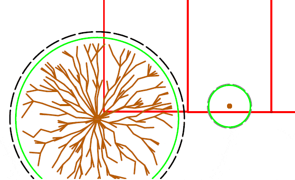
Adding Tree Radar Survey Results to Existing Topographical Surveys
Using the outputs from the Tree Radar analysis suite and CAD software we are able to insert various graphics directly into your existing topographical surveys. This service enables easy viewing and understanding of the results for all parties involved.
The data that is inserted is scaled to the correct size and correctly oriented to ensure pinpoint accuracy for using the results in the planning works and on site operations.
What is different between our Tree Radar Unit™ and similar units in the UK?
Our TRU™ was specifically designed to work with conditions that we commonly find in the UK and to deal with the working parameters of planning requirements. We operate a TRU™ using a 900Mhz antenna that has an effective working range of up to 1.5m depth depending on the soil conditions.
The 900mhz antenna is highly accurate within theses ranges, especially in the shallower spectrum between 0 and 750mm. These parameters are critical for the fact that most trees in the UK utilize the top 600mm of soil for the bulk of their rooting.
The majority of other TRU™ systems that are in use in Europe operate a 400Mhz antenna, this means the units can penetrate to much greater depths, up to 4m in some cases. However with the increases in depth capability there is far less clarity and scope for detecting smaller roots, this can leave some scans lacking in detail and therefore quality.
FAQ's on Tree Radar
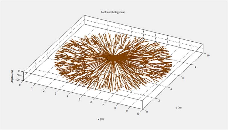
Tree Radar is a technology that uses ground-penetrating radar (GPR) to produce high-resolution images of tree roots and subsurface structures. It is used by arborists and tree care professionals to assess tree health, diagnose tree problems, and develop targeted tree care plans.
A Tree Radar Unit is a specialized device that uses GPR technology to produce images of tree roots and subsurface structures. It typically consists of a control unit, a transmitter, and a receiver, and can be used in conjunction with specialised software to analyze the data and produce detailed reports.
Tree Radar works by emitting electromagnetic pulses into the soil using a transmitter and measuring the reflected signals with a receiver. These signals are then processed and analysed using specialised software to produce images of tree roots and other subsurface structures.
The benefits of using Tree Radar include the ability to assess tree health and diagnose problems that are not visible from the surface, such as root decay or damage to underground structures. This can help tree care professionals to develop targeted tree care plans and improve overall tree health.
Tree Radar can be used in a variety of situations, such as when assessing the health of mature trees, diagnosing tree problems, or developing tree care plans. It is particularly useful in situations where root growth or subsurface structures are a concern, such as when planting new trees or constructing near existing trees.
The limitations of Tree Radar include the need for specialised training and expertise to interpret the data, as well as the potential for interference from nearby structures or other sources of electromagnetic radiation. It is important to consult with a qualified arborist or tree care professional when using Tree Radar.
Data is collected by scanning the area around the tree using the transmitter and receiver. The data is then processed and analysed using specialised software to produce images of the tree roots and subsurface structures. The resulting data can be used to develop targeted tree care plans or to diagnose tree problems.
Yes! We are able to scan through reinforced concrete. During the data analysis we can exclude the area of reinforcing material and just locate tree roots beneath it. In most cases we are also able to tell you how deep the concrete layer is as well. This is useful when scanning areas such as driveways, outbuildings or even pavements.
This is where we use ground penetrating radar to scan an area and detect the location of tree roots within the soil. We can penetrate to a depth of up to 1.2m, plot the locations and depths of tree roots and map them onto a variety of graphical outputs. The Tree Root Radar scans are a great solution for scanning through concrete, tarmac and large areas that would be impractical to excavate using the airspade system.
We can scan to a maximum depth of 1.2m in good conditions although this is variable depending on the soil composition and moisture content. Most trees in the UK utilise the top 60cm of soil for the bulk of their rooting activities (BS5837.2012) so scanning to this depth is more than sufficient for most planning applications.

Professional Service
Impartial, Accurate, High quality reports
Fast Turnaround
Reports typically delivered within 24hrs
Experienced
Many years experience with trees & planning

Full Insurance
Public Liability, Professional indemnity & Employers Liability